Tour de France 2027
- Distance
- 3,479 km
- Elevation gain
- 53,450 m
- When
- 2–25 July 2027
- Course
- Edinburgh → Paris
- Stages
- 21 + 3 rest days
Loading map…
Stage 1 · Edinburgh → Carlisle
Official stage ↗Flat185 km↑ 2,000 m
S: start · F: finish · Numbers: catalogue approach starts. The road route is not plotted.
Elevation profile
Open full-size profile ↗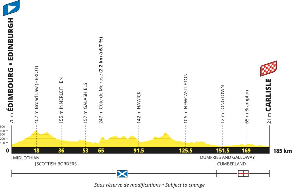
Explore the climbs
Our catalogue approaches are listed in race order. Their full length and gradient can differ from the race’s categorised section.
| № | Catalogue approach | Length | Gain | Avg. |
|---|---|---|---|---|
| 1 | Côte de Melrose / Bowden Loch ↗ | 2.8 km | 157 m | 5.4% |
Stage 2 · Keswick → Liverpool
Official stage ↗Hilly223 km↑ 3,000 m
S: start · F: finish · Numbers: catalogue approach starts. The road route is not plotted.
Elevation profile
Open full-size profile ↗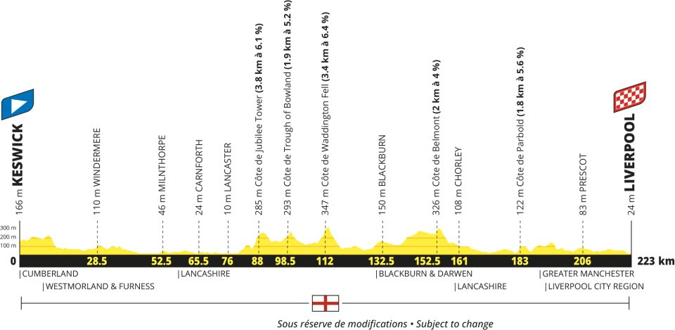
Explore the climbs
Our catalogue approaches are listed in race order. Their full length and gradient can differ from the race’s categorised section.
| № | Catalogue approach | Length | Gain | Avg. |
|---|---|---|---|---|
| 1 | Jubilee Tower via Quernmore ↗ | 4.1 km | 235 m | 5.7% |
| 2 | Waddington Fell from Newton-in-Bowland ↗ | 3.5 km | 226 m | 6.4% |
Stage 3 · Welshpool → Cardiff
Official stage ↗Hilly223 km↑ 3,000 m
S: start · F: finish · Numbers: catalogue approach starts. The road route is not plotted.
Elevation profile
Open full-size profile ↗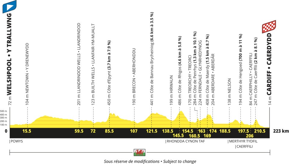
Explore the climbs
Our catalogue approaches are listed in race order. Their full length and gradient can differ from the race’s categorised section.
| № | Catalogue approach | Length | Gain | Avg. |
|---|---|---|---|---|
| 1 | Côte de Rhigos from Hirwaun ↗ | 5.7 km | 285 m | 5.0% |
| 2 | Caerphilly Mountain / Côte de Caerphilly ↗ | 1.4 km | 137 m | 9.6% |
Stage 4 · Cherbourg-en-Cotentin → Cherbourg-en-Cotentin
Official stage ↗Hilly171 km↑ 2,200 m
S: start · F: finish · Numbers: catalogue approach starts. The road route is not plotted.
Elevation profile
Open full-size profile ↗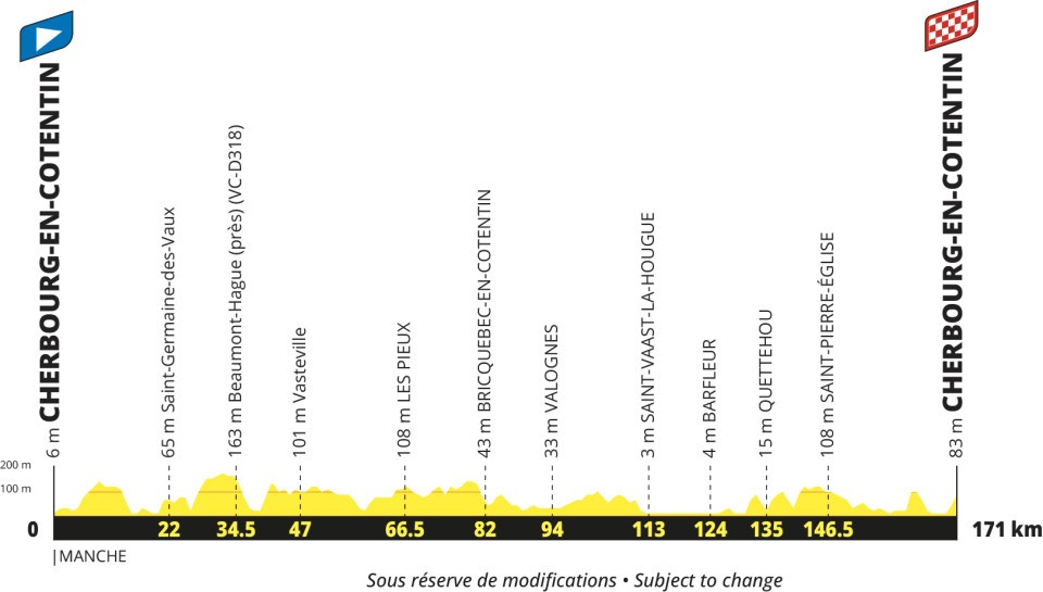
Stage 5 · Pontorson → Plumelec
Official stage ↗Hilly178 km↑ 1,900 m
S: start · F: finish · Numbers: catalogue approach starts. The road route is not plotted.
Elevation profile
Open full-size profile ↗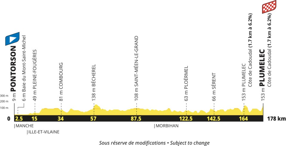
Explore the climbs
Our catalogue approaches are listed in race order. Their full length and gradient can differ from the race’s categorised section.
| № | Catalogue approach | Length | Gain | Avg. |
|---|---|---|---|---|
| 1 | Côte de Cadoudal ↗ | 1.8 km | 113 m | 6.2% |
Stage 6 · Vannes → Angers
Official stage ↗Hilly193 km↑ 1,500 m
S: start · F: finish · Numbers: catalogue approach starts. The road route is not plotted.
Elevation profile
Open full-size profile ↗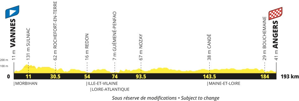
Stage 7 · Blois → Chambord
Official stage ↗Individual time-trial38 km↑ 200 m
S: start · F: finish · Numbers: catalogue approach starts. The road route is not plotted.
Elevation profile
Open full-size profile ↗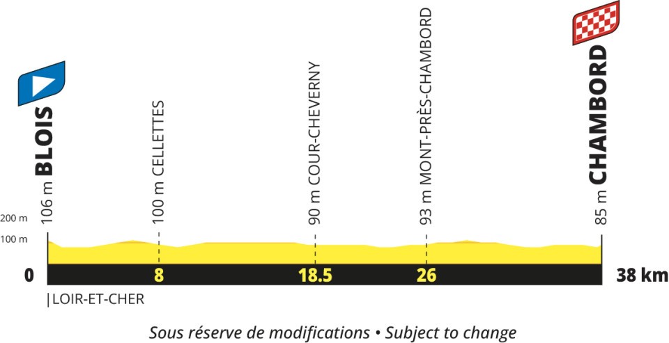
Stage 8 · Bourges → Le Creusot
Official stage ↗Hilly224 km↑ 3,100 m
S: start · F: finish · Numbers: catalogue approach starts. The road route is not plotted.
Elevation profile
Open full-size profile ↗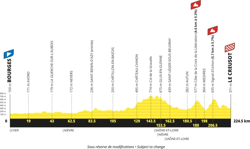
Explore the climbs
Our catalogue approaches are listed in race order. Their full length and gradient can differ from the race’s categorised section.
| № | Catalogue approach | Length | Gain | Avg. |
|---|---|---|---|---|
| 1 | Signal d'Uchon / Mont Julien from Les Sertaux ↗ | 5.8 km | 386 m | 6.5% |
Stage 9 · Villars-les-Dombes Parc des Oiseaux → Grand Colombier
Official stage ↗Mountain162 km↑ 3,750 m
S: start · F: finish · Numbers: catalogue approach starts. The road route is not plotted.
Elevation profile
Open full-size profile ↗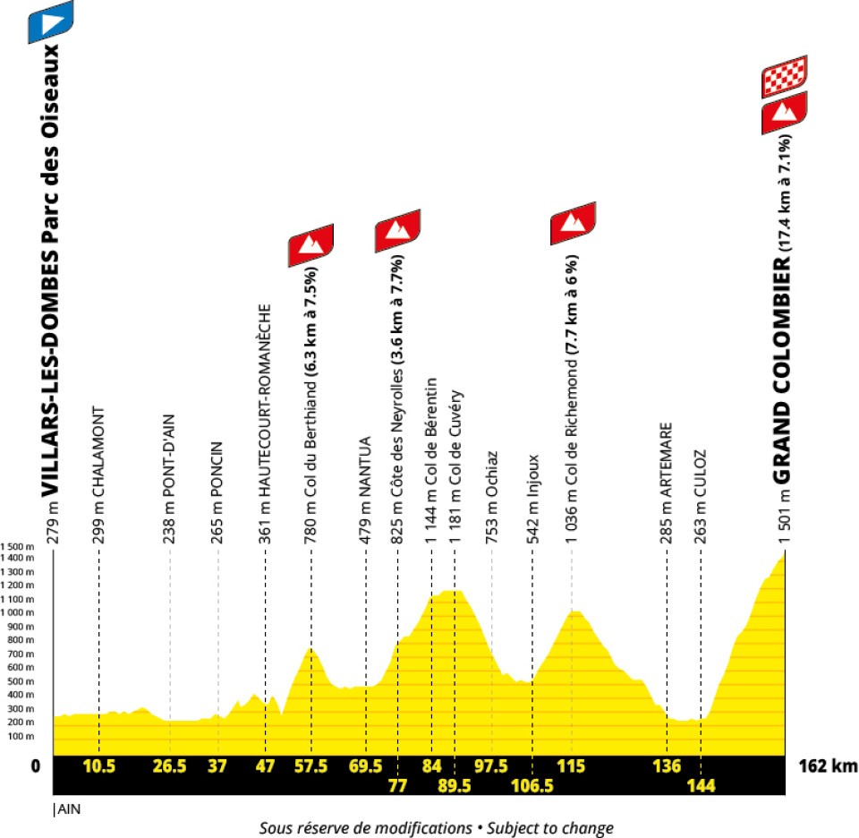
Explore the climbs
Our catalogue approaches are listed in race order. Their full length and gradient can differ from the race’s categorised section.
| № | Catalogue approach | Length | Gain | Avg. |
|---|---|---|---|---|
| 1 | Col de Berthiand from Serrières sur Ain ↗ | 6.4 km | 491 m | 7.7% |
| 2 | Col du Grand Colombier from Culoz ↗ | 17.6 km | 1,258 m | 7.1% |
Stage 10 · Annecy → Sallanches
Official stage ↗Mountain171 km↑ 3,750 m
S: start · F: finish · Numbers: catalogue approach starts. The road route is not plotted.
Elevation profile
Open full-size profile ↗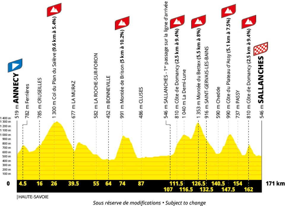
Explore the climbs
Our catalogue approaches are listed in race order. Their full length and gradient can differ from the race’s categorised section.
| № | Catalogue approach | Length | Gain | Avg. |
|---|---|---|---|---|
| 1 | Côte de Domancy from Domancy ↗ | 2.5 km | 219 m | 8.7% |
Stage 11 · Cluses → Les Saisies
Official stage ↗Mountain150 km↑ 4,750 m
S: start · F: finish · Numbers: catalogue approach starts. The road route is not plotted.
Elevation profile
Open full-size profile ↗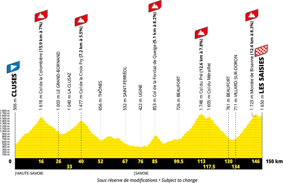
Explore the climbs
Our catalogue approaches are listed in race order. Their full length and gradient can differ from the race’s categorised section.
| № | Catalogue approach | Length | Gain | Avg. |
|---|---|---|---|---|
| 1 | Col de la Colombière from Scionzier ↗ | 16.2 km | 1,110 m | 6.9% |
| 2 | Col du Pré from Beaufort ↗ | 12.2 km | 966 m | 7.9% |
Stage 12 · Chambéry → Valence
Official stage ↗Flat162 km↑ 1,600 m
S: start · F: finish · Numbers: catalogue approach starts. The road route is not plotted.
Elevation profile
Open full-size profile ↗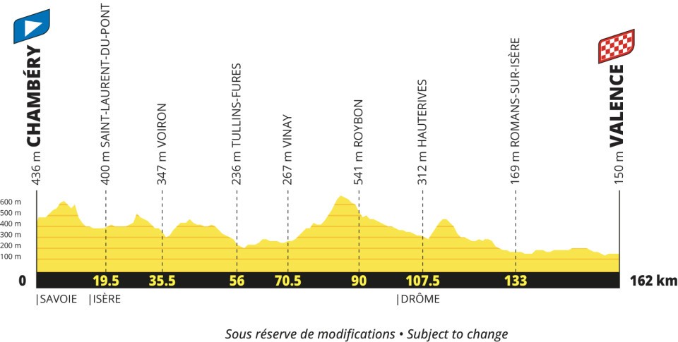
Stage 13 · Aubenas → Montpellier
Official stage ↗Flat164 km↑ 1,500 m
S: start · F: finish · Numbers: catalogue approach starts. The road route is not plotted.
Elevation profile
Open full-size profile ↗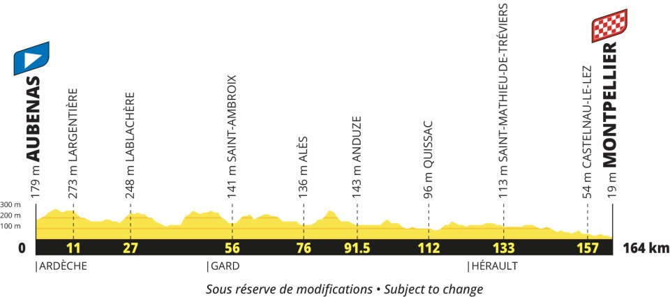
Stage 14 · Montpellier → Mende
Official stage ↗Mountain199 km↑ 4,300 m
S: start · F: finish · Numbers: catalogue approach starts. The road route is not plotted.
Elevation profile
Open full-size profile ↗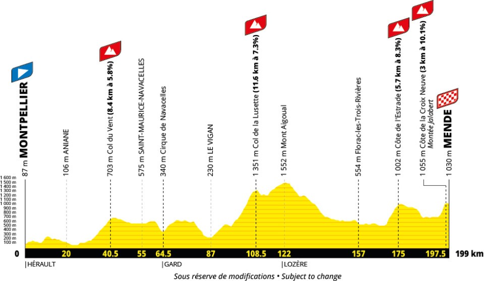
Explore the climbs
Our catalogue approaches are listed in race order. Their full length and gradient can differ from the race’s categorised section.
| № | Catalogue approach | Length | Gain | Avg. |
|---|---|---|---|---|
| 1 | Côte de la Croix Neuve / Montée Laurent Jalabert ↗ | 2.7 km | 297 m | 10.9% |
Stage 15 · Rodez → Albi
Official stage ↗Hilly169 km↑ 2,500 m
S: start · F: finish · Numbers: catalogue approach starts. The road route is not plotted.
Elevation profile
Open full-size profile ↗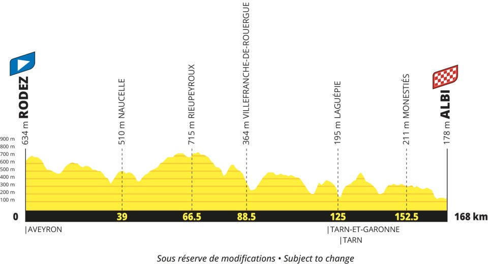
Stage 16 · Toulouse → Toulouse
Official stage ↗Individual time-trial33 km↑ 200 m
S: start · F: finish · Numbers: catalogue approach starts. The road route is not plotted.
Elevation profile
Open full-size profile ↗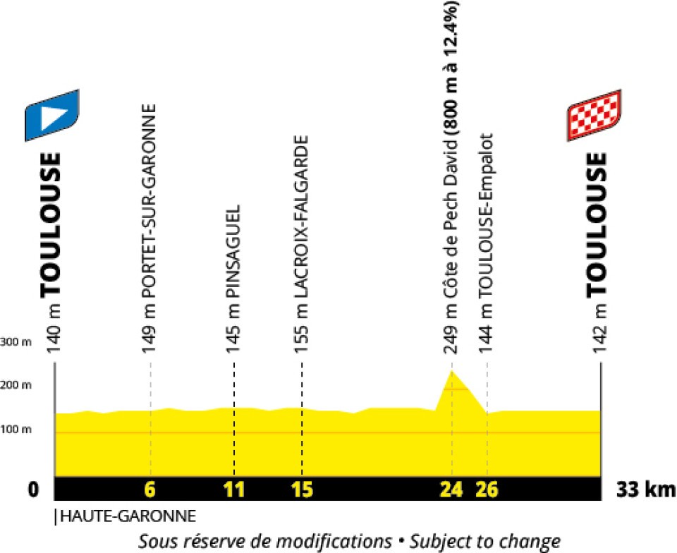
Stage 17 · Muret → Pau
Official stage ↗Flat186 km↑ 2,000 m
S: start · F: finish · Numbers: catalogue approach starts. The road route is not plotted.
Elevation profile
Open full-size profile ↗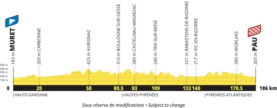
Stage 18 · Pau → Saint-Lary-Soulan Col du Portet
Official stage ↗Mountain174 km↑ 5,400 m
S: start · F: finish · Numbers: catalogue approach starts. The road route is not plotted.
Elevation profile
Open full-size profile ↗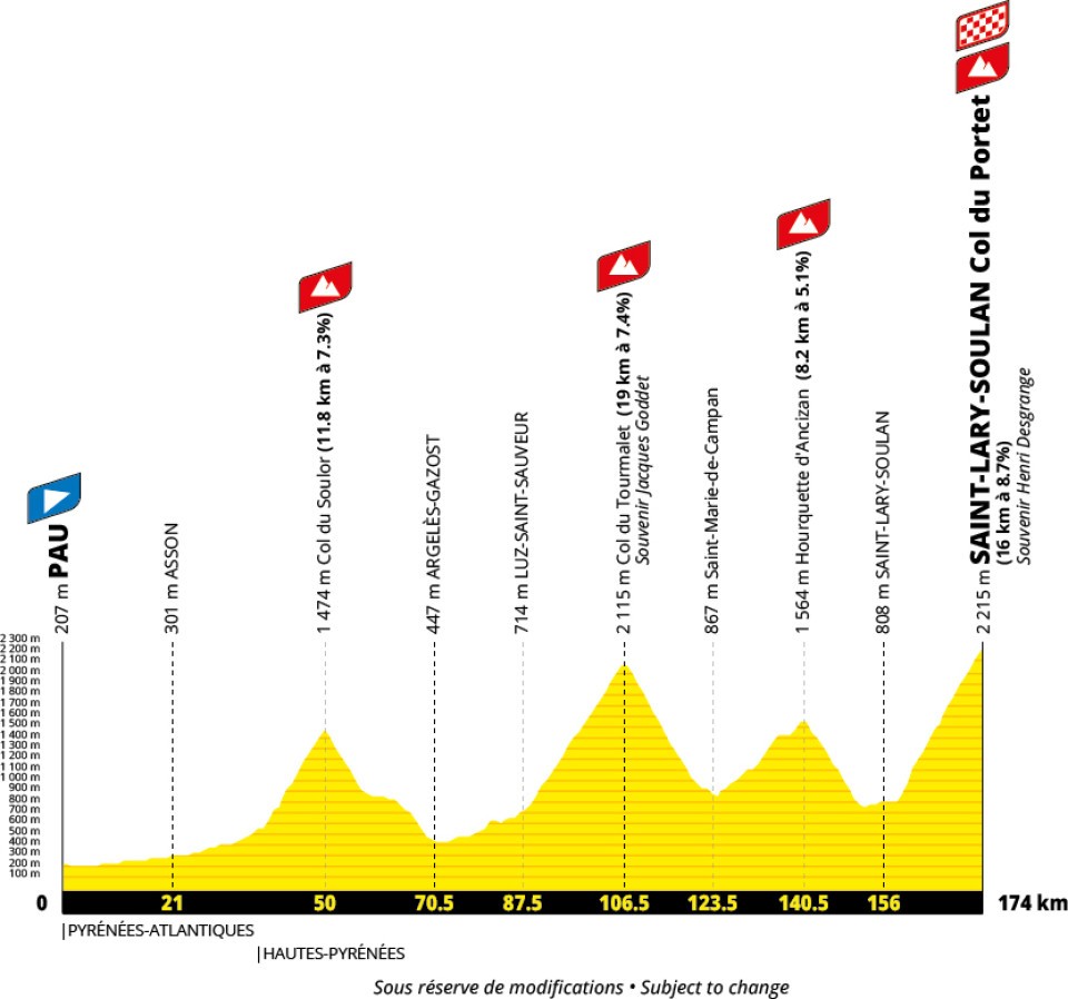
Explore the climbs
Our catalogue approaches are listed in race order. Their full length and gradient can differ from the race’s categorised section.
| № | Catalogue approach | Length | Gain | Avg. |
|---|---|---|---|---|
| 1 | Col du Soulor from Ferrières ↗ | 12.0 km | 916 m | 7.7% |
| 2 | Col du Tourmalet from Luz Saint Sauveur via Super Barèges ↗ | 18.9 km | 1,400 m | 7.4% |
| 3 | Col de Portet from Saint Lary Soulan ↗ | 16.1 km | 1,393 m | 8.6% |
Stage 19 · Hasparren → Laruns
Official stage ↗Mountain160 km↑ 4,300 m
S: start · F: finish · Numbers: catalogue approach starts. The road route is not plotted.
Elevation profile
Open full-size profile ↗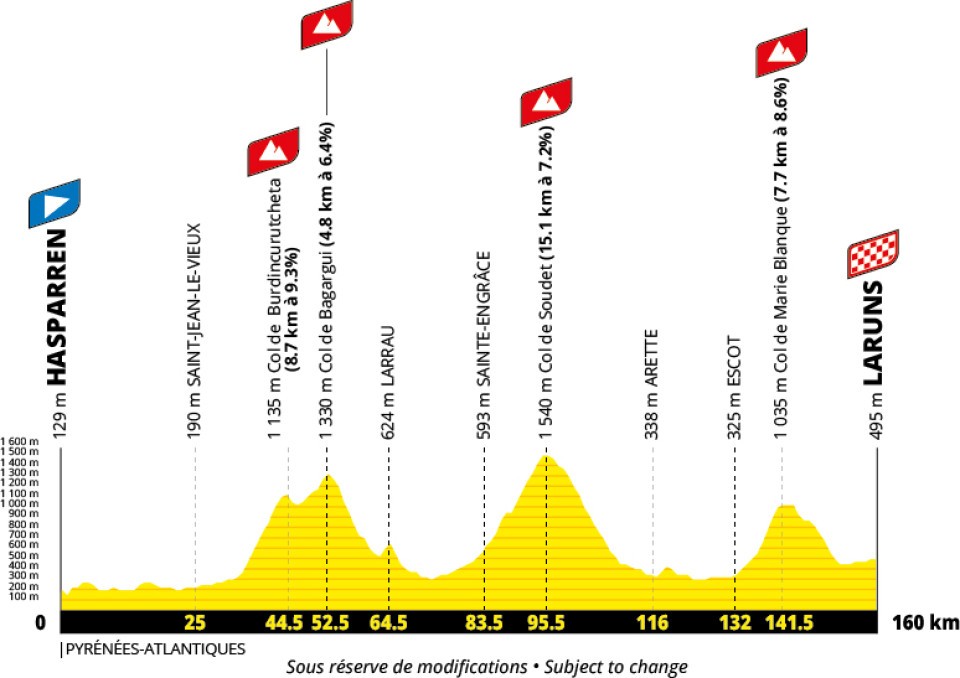
Explore the climbs
Our catalogue approaches are listed in race order. Their full length and gradient can differ from the race’s categorised section.
| № | Catalogue approach | Length | Gain | Avg. |
|---|---|---|---|---|
| 1 | Col de Burdincurutcheta from Bassaburua ↗ | 9.1 km | 817 m | 8.9% |
| 2 | Col de Marie-Blanque from Escot ↗ | 9.1 km | 701 m | 7.7% |
Stage 20 · Maubourguet → Libourne
Official stage ↗Flat198 km↑ 1,700 m
S: start · F: finish · Numbers: catalogue approach starts. The road route is not plotted.
Elevation profile
Open full-size profile ↗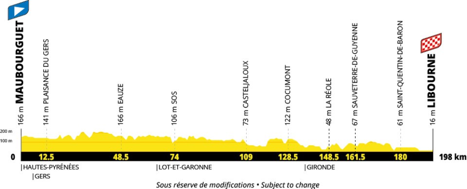
Stage 21 · Saint-Quentin-en-Yvelines → Paris Champs-Élysées
Official stage ↗Flat116 km↑ 800 m
S: start · F: finish · Numbers: catalogue approach starts. The road route is not plotted.
Elevation profile
Open full-size profile ↗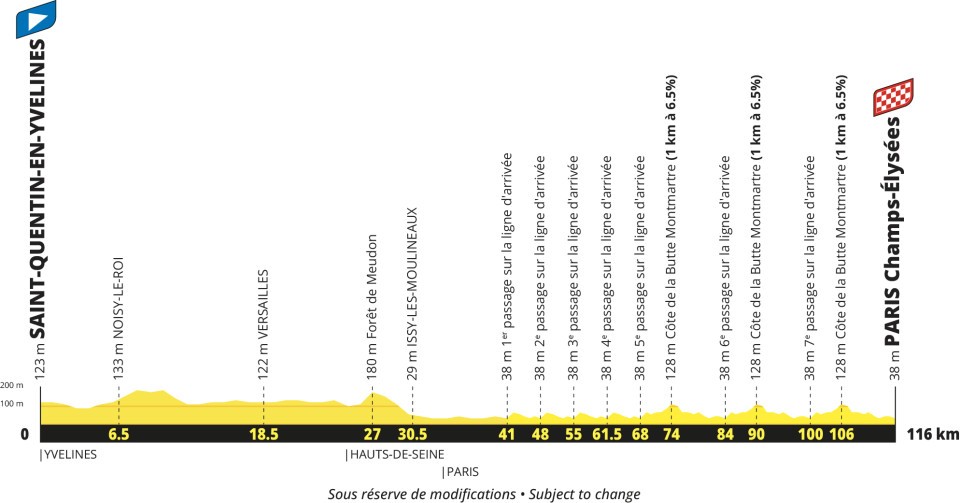
Explore the climbs
Our catalogue approaches are listed in race order. Their full length and gradient can differ from the race’s categorised section.
| № | Catalogue approach | Length | Gain | Avg. |
|---|---|---|---|---|
| 1 | Montmartre via Rue Lepic ↗ | 0.9 km | 56 m | 6.4% |
All stages
| Stage | Route | Distance | Gain |
|---|---|---|---|
| 1 | Edinburgh → Carlisle · Flat | 185 km | 2,000 m |
| 2 | Keswick → Liverpool · Hilly | 223 km | 3,000 m |
| 3 | Welshpool → Cardiff · Hilly | 223 km | 3,000 m |
| — | Rest day · Cherbourg-en-Cotentin | — | — |
| 4 | Cherbourg-en-Cotentin → Cherbourg-en-Cotentin · Hilly | 171 km | 2,200 m |
| 5 | Pontorson → Plumelec · Hilly | 178 km | 1,900 m |
| 6 | Vannes → Angers · Hilly | 193 km | 1,500 m |
| 7 | Blois → Chambord · Individual time-trial | 38 km | 200 m |
| 8 | Bourges → Le Creusot · Hilly | 224 km | 3,100 m |
| 9 | Villars-les-Dombes Parc des Oiseaux → Grand Colombier · Mountain | 162 km | 3,750 m |
| — | Rest day · Haute-Savoie | — | — |
| 10 | Annecy → Sallanches · Mountain | 171 km | 3,750 m |
| 11 | Cluses → Les Saisies · Mountain | 150 km | 4,750 m |
| 12 | Chambéry → Valence · Flat | 162 km | 1,600 m |
| 13 | Aubenas → Montpellier · Flat | 164 km | 1,500 m |
| 14 | Montpellier → Mende · Mountain | 199 km | 4,300 m |
| 15 | Rodez → Albi · Hilly | 169 km | 2,500 m |
| — | Rest day · Toulouse | — | — |
| 16 | Toulouse → Toulouse · Individual time-trial | 33 km | 200 m |
| 17 | Muret → Pau · Flat | 186 km | 2,000 m |
| 18 | Pau → Saint-Lary-Soulan Col du Portet · Mountain | 174 km | 5,400 m |
| 19 | Hasparren → Laruns · Mountain | 160 km | 4,300 m |
| 20 | Maubourguet → Libourne · Flat | 198 km | 1,700 m |
| 21 | Saint-Quentin-en-Yvelines → Paris Champs-Élysées · Flat | 116 km | 800 m |
The 2027 route
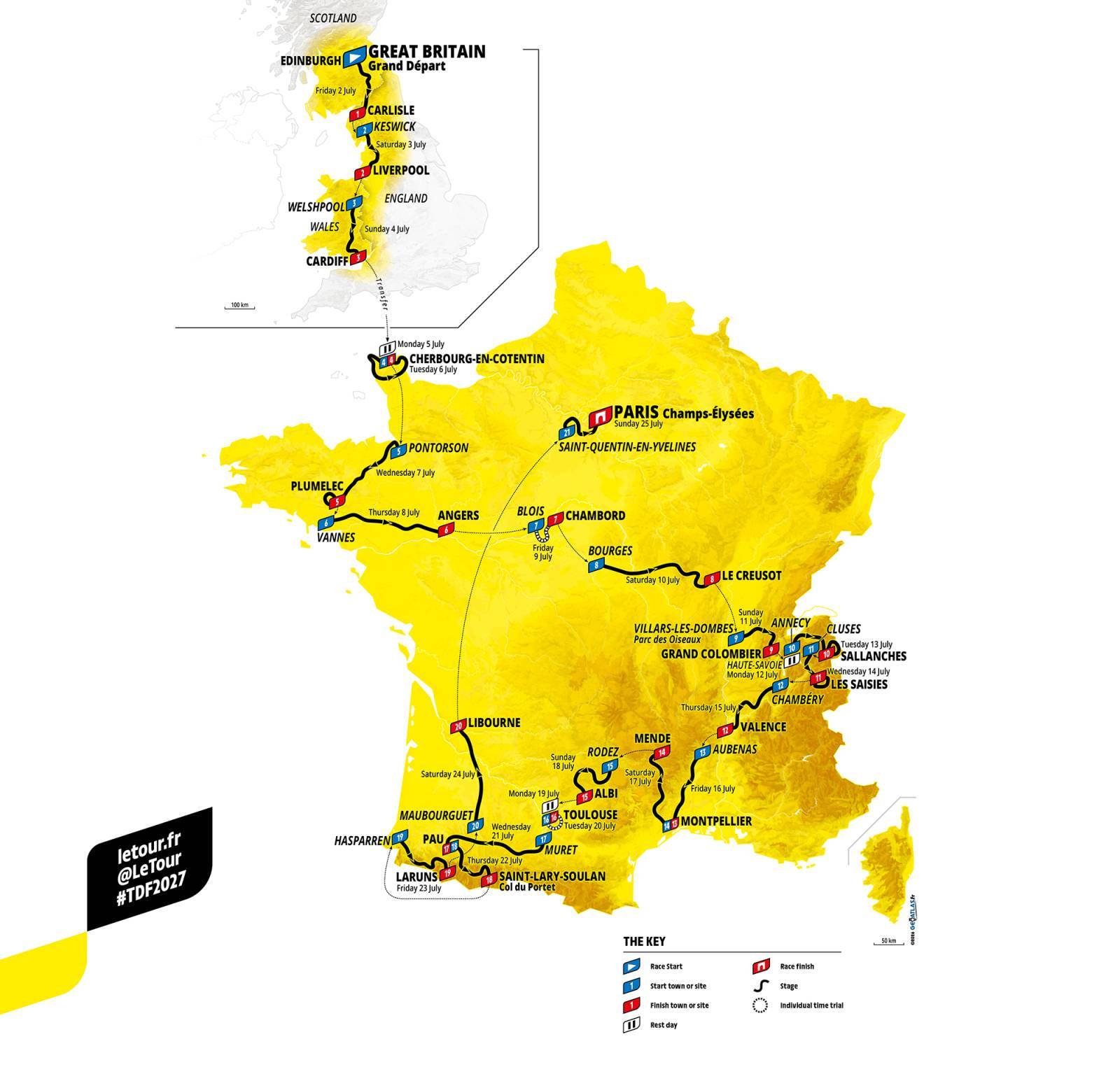
© A.S.O. · Official route · Download route PDF ↗
Route announced 22 October 2026. Distances are subject to homologation. Checked 25 October 2026.
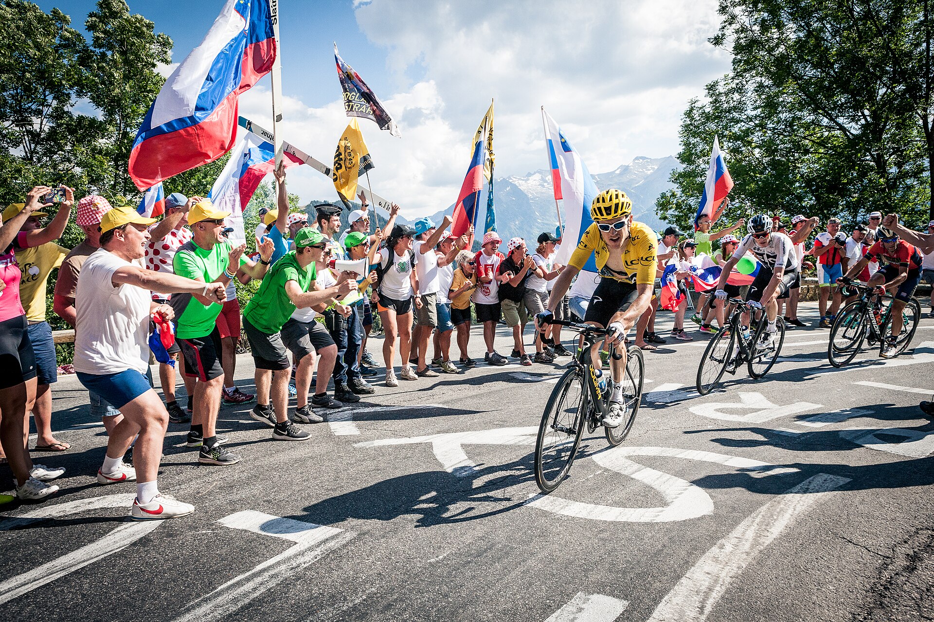
Cover: Geraint Thomas and Chris Froome climbing Alpe d’Huez at the 2018 Tour de France.